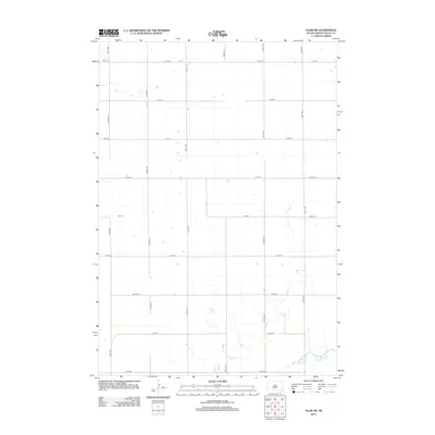
2012 Map of Agar SW
USGS Topo · Published 2012About this map
Okobojo Cr meanders through the southern reaches of this Sully County landscape, providing the primary hydrological feature in an otherwise strictly partitioned prairie. The terrain is defined by the rigid geometry of the Public Land Survey System, expressed here through a dense grid of section-line roads such as 174th St and 301st Ave. This 2012 survey by the U.S. Geological Survey illustrates the enduring spatial organization of South Dakota's agricultural heartland, where occasional farmsteads are linked by a precise network of avenues and streets. The contrast between the wandering path of the creek and the unwavering straightness of 182nd St highlights the intersection of natural drainage and human engineering in this rural corridor.
Find a feature on this map
16 named features on this map. Tap any name to fly to it.
Don’t see what you’re looking for? This feature index may not catch every label — zoom into the map to look around manually.
Map Details
Editions of this 2012 Agar SW Map
This is the sole edition of this map. No revisions or reprints were ever made.
Other maps of this area

1954 · Pierre
USGS Topo · 1:250,000

1958 · Pierre
USGS Topo · 1:250,000

1965 · Artichoke Butte
USGS Topo · 1:24,000

1965 · Agar SW
USGS Topo · 1:24,000

1965 · Okobojo NE
USGS Topo · 1:24,000

1965 · Agar
USGS Topo · 1:24,000

1965 · Sully Lake
USGS Topo · 1:24,000

1970 · Agar NW
USGS Topo · 1:24,000
1970 · Agar NE
USGS Topo · 1:24,000
1970 · Artichoke Butte NE
USGS Topo · 1:24,000