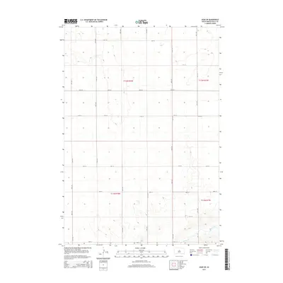
2015 Map of Agar SW
USGS Topo · Published 2015About this map
Okobojo Creek winds through the southeastern portion of this Sully County landscape, carving a subtle drainage pattern into the high plains of South Dakota. The area is defined by the strict rectilinear logic of the Public Land Survey System, featuring township boundaries such as t116n r78w and t115n r78w. A sparse but rhythmic grid of section lines and gravel roads, including 176th St and 300th Ave, organizes the agricultural terrain. This survey from the U.S. Geological Survey shows a landscape almost entirely dedicated to large-scale ranching or dryland farming, with very few structures or named settlements interrupting the vast, open spaces of the Missouri Plateau. The few water features, like Okobojo Cr, represent critical landmarks in this semi-arid region where topographic relief is minimal and the horizon is dominated by the geometric alignment of rural routes.
Find a feature on this map
20 named features on this map. Tap any name to fly to it.
Don’t see what you’re looking for? This feature index may not catch every label — zoom into the map to look around manually.
Map Details
Editions of this 2015 Agar SW Map
This is the sole edition of this map. No revisions or reprints were ever made.
Other maps of this area

1954 · Pierre
USGS Topo · 1:250,000

1958 · Pierre
USGS Topo · 1:250,000

1965 · Artichoke Butte
USGS Topo · 1:24,000

1965 · Agar SW
USGS Topo · 1:24,000

1965 · Okobojo NE
USGS Topo · 1:24,000

1965 · Agar
USGS Topo · 1:24,000

1965 · Sully Lake
USGS Topo · 1:24,000

1970 · Agar NW
USGS Topo · 1:24,000
1970 · Agar NE
USGS Topo · 1:24,000
1970 · Artichoke Butte NE
USGS Topo · 1:24,000