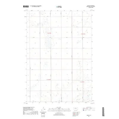
2017 Map of Agar SW
USGS Topo · Published 2017About this map
Okobojo Cr winds through the southeastern corner of this Sully County landscape, defining the primary drainage for a region characterized by section-line roads and extensive wetland basins. The area is dominated by the Public Land Survey System grid, which is clearly marked by townships such as t116n r78w and t115n r77w. This survey provides a precise view of the local transportation network that connects the rural farmsteads, including thoroughfares like Agar Rd and 301st Ave. The numerous unnamed wetlands scattered across the northern sections suggest a prairie pothole environment, vital for local hydrology. Genealogists and local historians can use the intersection of roads like 174th St and 297th Ave to pinpoint specific historical land holdings and early 21st-century rural developments.
Find a feature on this map
19 named features on this map. Tap any name to fly to it.
Don’t see what you’re looking for? This feature index may not catch every label — zoom into the map to look around manually.
Map Details
Editions of this 2017 Agar SW Map
This is the sole edition of this map. No revisions or reprints were ever made.
Other maps of this area

1954 · Pierre
USGS Topo · 1:250,000

1958 · Pierre
USGS Topo · 1:250,000

1965 · Artichoke Butte
USGS Topo · 1:24,000

1965 · Agar SW
USGS Topo · 1:24,000

1965 · Okobojo NE
USGS Topo · 1:24,000

1965 · Agar
USGS Topo · 1:24,000

1965 · Sully Lake
USGS Topo · 1:24,000

1970 · Agar NW
USGS Topo · 1:24,000
1970 · Agar NE
USGS Topo · 1:24,000
1970 · Artichoke Butte NE
USGS Topo · 1:24,000