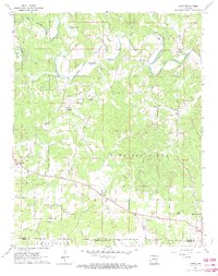
1962 Map of Agnos
USGS Topo · Published 1973About this map
Pleasant Ridge anchors the central landscape of this survey, which captures the rural character of the Ozark foothills at the start of the 1960s. The terrain is defined by the winding course of the South Fork Spring River and Myatt Fork, which dictated the early settlement patterns and road networks between Agnos and Glencoe. This map is particularly valuable for genealogists and local historians, as it records several small rural congregations and burial grounds, including Heart Ch, Nazarene Ch, Rhoads Cem, and Humphries Cem. The distribution of these landmarks, alongside smaller communities like Heart and Saddle, reveals a decentralized social structure centered on valley farms and ridge-top crossroads. A small Quarry located in the south-east provides a rare indication of local industrial activity amidst the largely agricultural and topographical focus of the region.
Find a feature on this map
32 named features on this map. Tap any name to fly to it.
Don’t see what you’re looking for? This feature index may not catch every label — zoom into the map to look around manually.
Map Details
Editions of this 1962 Agnos Map
3 editions found
Other maps of this area

1950 · Salem
USGS Topo · 1:62,500

1951 · Salem
USGS Topo · 1:62,500

1951 · Melbourne
USGS Topo · 1:62,500

1957 · Poplar Bluff
USGS Topo · 1:250,000

1959 · Poplar Bluff
USGS Topo · 1:250,000

1960 · Poplar Bluff
USGS Topo · 1:250,000

1962 · Stuart
USGS Topo · 1:24,000

1962 · Ash Flat
USGS Topo · 1:24,000

1962 · Myron
USGS Topo · 1:24,000

1962 · Agnos
USGS Topo · 1:24,000