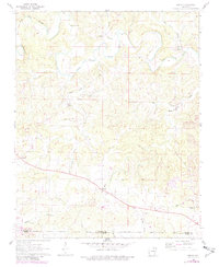
1962 Map of Agnos
USGS Topo · Published 1982About this map
The South Fork Spring River and its many meandering tributaries define the landscape of this northern Arkansas region during the early 1960s. Small, dispersed settlements like Agnos, Heart, and French are connected by a network of rural roads, with many homesteads and properties delineated by fence and field lines visible from 1959 aerial photography. The presence of several historic spiritual and burial sites, including Barks Chapel, Heart Ch, and Rhoads Cem, provides a detailed record of the community's social geography. Near the southern border, the early development of Horseshoe Bend is visible where the terrain transitions toward Izard County. The map also documents local industry through landmarks like the Quarry near Neely Creek and the Pit in the southeast, while the winding courses of Wild Horse Creek and Lick Creek illustrate the natural drainage patterns that shaped local settlement before more modern infrastructure arrived.
Find a feature on this map
28 named features on this map. Tap any name to fly to it.
Don’t see what you’re looking for? This feature index may not catch every label — zoom into the map to look around manually.
Map Details
Editions of this 1962 Agnos Map
3 editions found
Other maps of this area

1950 · Salem
USGS Topo · 1:62,500

1951 · Salem
USGS Topo · 1:62,500

1951 · Melbourne
USGS Topo · 1:62,500

1957 · Poplar Bluff
USGS Topo · 1:250,000

1959 · Poplar Bluff
USGS Topo · 1:250,000

1960 · Poplar Bluff
USGS Topo · 1:250,000

1962 · Stuart
USGS Topo · 1:24,000

1962 · Ash Flat
USGS Topo · 1:24,000

1962 · Myron
USGS Topo · 1:24,000

1962 · Agnos
USGS Topo · 1:24,000