Loading...
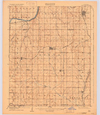
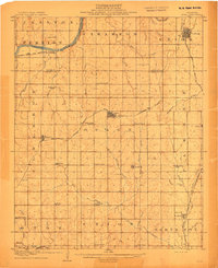
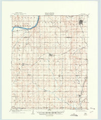
Loading map...1908 Map of Agra
USGS Topo · Published 1931About this map
Agra and the surrounding borderlands of Payne and Lincoln counties were surveyed in 1906, shortly before Oklahoma achieved statehood. This landscape is defined by the winding course of the Cimarron River in the north and a dense network of early territorial schools that served the dispersed farming communities. Distinctive names like Hardscrabble School, Free Silver School, and Valley Queen School reflect the local character and values of these agrarian settlements during the land run era.
Find a feature on this map
52 named features on this map. Tap any name to fly to it.
Don’t see what you’re looking for? This feature index may not catch every label — zoom into the map to look around manually.
Map Details
Date Portrayed1908
Date Published1931
PublisherU.S. Geological Survey
Map TypeTopographic
Scale1:62,500
Physical Dimensions17.5 x 20.1 inches
Editions of this 1908 Agra Map
3 editions found
Historical Maps of Cushing Through Time
1 maps found
Featured Locations
Source Details
SourceU.S. Geological Survey
CopyrightPublic Domain