Loading...
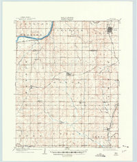
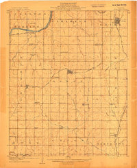
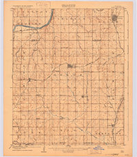
Loading map...1908 Map of Agra
USGS Topo · Published 1949About this map
The Cimarron River winds through the northern reaches of this territory, where the early twentieth-century landscape was defined by its transition from prairie to an organized network of rural school districts and small rail towns. Surveyed just before statehood, the area shows the vital role of the Atchison Topeka and Santa Fe RR and the Missouri Kansas and Texas RR in connecting nascent settlements like Cushing, Agra, and Tryon.
Find a feature on this map
48 named features on this map. Tap any name to fly to it.
Don’t see what you’re looking for? This feature index may not catch every label — zoom into the map to look around manually.
Map Details
Date Portrayed1908
Date Published1949
PublisherU.S. Geological Survey
Map TypeTopographic
Scale1:62,500
Physical Dimensions19 x 22.4 inches
Editions of this 1908 Agra Map
3 editions found
Historical Maps of Cushing Through Time
1 maps found
Featured Locations
Source Details
SourceU.S. Geological Survey
CopyrightPublic Domain