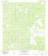
1980 Map of Agua Azul Creek West
USGS Topo · Published 1980About this map
Agua Azul Creek winds through this South Texas landscape along the border of Webb Co and Zapata Co. Recorded in the mid-1970s and edited by the U.S. Geological Survey in 1980, the terrain is defined by a network of intermittent drainages including Cerrito Creek, San Juanito Creek, and Barrocito Creek. The presence of Oil Wells and a prominent Landing Strip suggests the active industrial and ranching use of the land during this era. Water management is a visible priority in this arid environment, evidenced by scattered livestock reservoirs such as Los Lasos Tank and Jordan Tank. An Indefinite Boundary separates the two counties in the southern portion of the sheet, while private land designations and pipelines cut across the brush country, illustrating the intersection of energy infrastructure and traditional landholdings near El Jaral Creek.
Find a feature on this map
14 named features on this map. Tap any name to fly to it.
Don’t see what you’re looking for? This feature index may not catch every label — zoom into the map to look around manually.
Map Details
Editions of this 1980 Agua Azul Creek West Map
This is the sole edition of this map. No revisions or reprints were ever made.
Other maps of this area

1933 · Becerra Creek
USGS Topo · 1:62,500

1940 · Aguilares
USGS Topo · 1:62,500

1940 · Mogotes Hill
USGS Topo · 1:62,500

1942 · San Ygnacio
USGS Topo · 1:62,500

1956 · Mogotes Hill
USGS Topo · 1:62,500

1956 · Laredo
USGS Topo · 1:250,000

1980 · Blancas Creek North
USGS Topo · 1:24,000
1980 · Agua Azul Creek East
USGS Topo · 1:24,000
1980 · Mirando City
USGS Topo · 1:24,000
1980 · Blancas Creek South
USGS Topo · 1:24,000