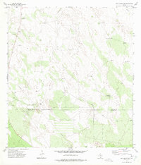
1972 Map of Agua Nueva SE
USGS Topo · Published 1975About this map
The boundary between Jim Hogg County and Starr County cuts through this South Texas landscape, defined by an arid brushland economy focused on ranching and energy extraction. Wind-powered water sources are the primary infrastructure for the region's cattle operations, evidenced by the numerous named landmarks such as Noria de Llano Windmill, San Manuel Windmill, and Brazil Windmill. The presence of Ramirito Ranch and the locality of Particion provide evidence of long-standing land divisions and settlement patterns in this remote corner of the Rio Grande plain.
Find a feature on this map
16 named features on this map. Tap any name to fly to it.
Don’t see what you’re looking for? This feature index may not catch every label — zoom into the map to look around manually.
Map Details
Editions of this 1972 Agua Nueva SE Map
2 editions found
Other maps of this area

1938 · Agua Nueva
USGS Topo · 1:62,500

1938 · Sal Colorada
USGS Topo · 1:62,500

1939 · La Reforma
USGS Topo · 1:62,500

1939 · Encantada
USGS Topo · 1:62,500

1949 · Mc Allen
USGS Topo · 1:250,000

1954 · McAllen
USGS Topo · 1:250,000

1957 · Mc Allen
USGS Topo · 1:250,000

1962 · McAllen
USGS Topo · 1:250,000
1972 · San Isidro
USGS Topo · 1:24,000
1972 · Santa Elena NW
USGS Topo · 1:24,000