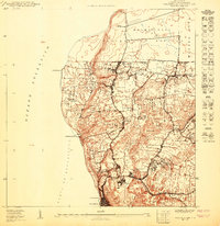
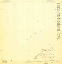
1950 Map of Aguadilla NE
USGS Topo · Published 1950About this map
The northwest coastline of Puerto Rico is dominated by the American Railroad Company of Porto Rico, which skirts the cliffs and coastal plains near Aguadilla. In this 1950 survey, the landscape is defined by traditional barrios like Borinquen, Maleza Baja, and Corrales, where dense clusters of housing appear at Caserío Raúl Esteves and Caserío José de Diego. The presence of the Reservación Militar and the Faro de Pta Borinquen lighthouse at the tip of Pta Borinquen highlights the strategic and navigational importance of this point where the Océano Atlántico meets the Bahía de Aguadilla. Several railroad sidings or bypasses, such as Desvío Camaceyes, Desvío Jiménez, and Desvío Maleza, indicate a specialized transportation infrastructure serving the local communities and agricultural production in the mid-20th century.
Find a feature on this map
25 named features on this map. Tap any name to fly to it.
Don’t see what you’re looking for? This feature index may not catch every label — zoom into the map to look around manually.
Map Details
Editions of this 1950 Aguadilla NE Map
This is the sole edition of this map. No revisions or reprints were ever made.
Other maps of this area

1937 · Aguadilla
USGS Topo · 1:20,000

1937 · Moca
USGS Topo · 1:20,000

1941 · Moca
USGS Topo · 1:30,000

1941 · Isabela
USGS Topo · 1:30,000

1942 · Moca
USGS Topo · 1:30,000

1942 · Aguadilla
USGS Topo · 1:30,000
1950 · Moca SO
USGS Topo · 1:10,000
1950 · Aguadilla SO
USGS Topo · 1:10,000
1950 · Moca NO
USGS Topo · 1:10,000
1950 · Aguadilla NNE
USGS Topo · 1:10,000
Featured Places
- Costa del Mar, Aguadilla
- Valles del Rocío, Aguadilla
- Reparto Ramos, Aguadilla
- Reparto Aguiar, Aguadilla
- Villas del Horizonte, Aguadilla