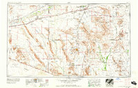
1958 Map of Ajo
USGS Topo · Published 1958About this map
The Gila River corridor and its associated Gila Bend Canal anchor the northern landscape of this mid-century desert survey, where agriculture met military expansion in the Arizona interior. The corridor is punctuated by the Southern Pacific railroad and a string of small sidings and settlements like Aztec, Dateland, and Theba. To the south, the isolated mining hub of Ajo sits adjacent to the sprawling Organ Pipe Cactus National Monument and the extensive Papago Indian Reservation.
Find a feature on this map
87 named features on this map. Tap any name to fly to it.
Don’t see what you’re looking for? This feature index may not catch every label — zoom into the map to look around manually.
Map Details
Editions of this 1958 Ajo Map
2 editions found

Other maps of this area

1913 · Maricopa
USGS Topo · 1:62,500

1914 · Gila Butte
USGS Topo · 1:62,500

1915 · Maricopa
USGS Topo · 1:62,500

1917 · Gila Butte
USGS Topo · 1:62,500

1922 · Casa Grande
USGS Topo · 1:62,500

1924 · Casa Grande
USGS Topo · 1:62,500

1926 · Wellton
USGS Topo · 1:62,500

1926 · Mohawk
USGS Topo · 1:62,500

1927 · Aguila Mountains
USGS Topo · 1:48,000

1927 · Kim
USGS Topo · 1:62,500