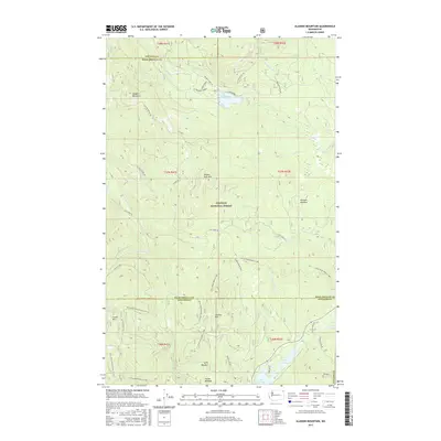
2017 Map of Aladdin Mountain
USGS Topo · Published 2017About this map
Colville National Forest dominates this section of the Selkirk Mountains, where the high ridges of Aladdin Mountain and Seldom Seen Mtn overlook a landscape of specialized alpine meadows and drainage basins. The boundary between Stevens and Pend Oreille counties cuts vertically through the eastern portion of the sheet, dividing a network of forestry and recreational routes. Among these are the Little Pend Oreille ORV trails and several forest development roads that provide access to the area's high-altitude water bodies. In the southern reaches, a chain of glacial lakes including Lake Leo, Lake Heritage, and Lake Thomas provides a distinct contrast to the northern creek systems. Named clearings like Stewart Meadow and Hills Meadow indicate the historical importance of these open spaces for early grazing or forest management in an otherwise densely timbered mountain environment.
Find a feature on this map
45 named features on this map. Tap any name to fly to it.
Don’t see what you’re looking for? This feature index may not catch every label — zoom into the map to look around manually.
Map Details
Editions of this 2017 Aladdin Mountain Map
This is the sole edition of this map. No revisions or reprints were ever made.
Other maps of this area

1929 · Colville
USGS Topo · 1:125,000

1933 · Colville
USGS Topo · 1:125,000

1934 · Metaline
USGS Topo · 1:125,000

1942 · Metaline
USGS Topo · 1:125,000

1952 · Spirit
USGS Topo · 1:24,000

1952 · Deep Lake
USGS Topo · 1:24,000

1952 · Aladdin
USGS Topo · 1:24,000

1958 · Sandpoint
USGS Topo · 1:250,000

1963 · Sandpoint
USGS Topo · 1:250,000
1966 · Aladdin
USGS Topo · 1:24,000