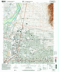
2006 Map of Alameda
USGS Topo · Published 2007About this map
The Rio Grande divides this landscape, with the historic Alameda and Corrales areas flanking its banks. Irrigation and drainage are critical to the river corridor, evidenced by the Corrales Main Canal and West Sandia Riverside Drain. To the east, the Sandia Indian Reservation and Sandia Pueblo Grant encompass the rising terrain of the Sandia Mountains, where Rincon Ridge and Pino Canyon overlook the growing northern reaches of Albuquerque. The map documents a blend of traditional land grants and modern suburban expansion, featuring landmarks like the International Balloon Museum near Balloon Fiesta Park. Local community life is centered around numerous institutions, from the Albuquerque LDS Temple and San Ysidro Church to the sprawling Albuquerque Academy campus and several cemeteries such as Gate of Heaven Cem.
Find a feature on this map
85 named features on this map. Tap any name to fly to it.
Don’t see what you’re looking for? This feature index may not catch every label — zoom into the map to look around manually.
Map Details
Editions of this 2006 Alameda Map
This is the sole edition of this map. No revisions or reprints were ever made.
Other maps of this area

1888 · Bernalillo
USGS Topo · 1:125,000

1889 · Albuquerque
USGS Topo · 1:125,000

1892 · San Pedro
USGS Topo · 1:125,000

1893 · Albuquerque
USGS Topo · 1:125,000

1934 · Alameda
USGS Topo · 1:24,000

1934 · West Albuquerque
USGS Topo · 1:24,000

1934 · Griegos
USGS Topo · 1:24,000

1934 · East Albuquerque
USGS Topo · 1:24,000

1938 · Albuquerque
USGS Topo · 1:62,500

1954 · Sandia Crest
USGS Topo · 1:24,000
Featured Places
- Albuquerque, NM
- Corrales, NM
- Los Ranchos de Albuquerque, NM
- Prospectors Ridge, Albuquerque
- Academy Ridge East, Albuquerque