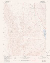
1969 Map of Alamo
USGS Topo · Published 1983About this map
Alamo serves as the focal point of this Nevada survey, situated within the fertile corridor of the Pahranagat Valley. The settlement is detailed with its Pahranagat Valley Sch, Rodeo Grounds, and the nearby Alamo Landing Field, illustrating the town's role as a regional hub for the surrounding ranching community. To the west, the landscape rises sharply into the East Pahranagat Range, a stark contrast to the riparian environment along the valley floor. To the southeast, the Pahranagat National Wildlife Refuge encompasses the Upper Pahranagat Lake, a critical water resource in the arid basin. Evidence of historical land use is found in scattered Ruins, a solitary Prospect in the hills, and the presence of Buckhorn Ranch. A network of Jeep Trails provides the primary access to the more remote springs and terrain features like Grove Spring.
Find a feature on this map
18 named features on this map. Tap any name to fly to it.
Don’t see what you’re looking for? This feature index may not catch every label — zoom into the map to look around manually.
Map Details
Editions of this 1969 Alamo Map
2 editions found
Other maps of this area

1945 · Alamo
USGS Topo · 1:125,000

1954 · Caliente
USGS Topo · 1:250,000

1959 · Caliente
USGS Topo · 1:250,000

1969 · Alamo SE
USGS Topo · 1:24,000

1969 · Lower Pahranagat Lake
USGS Topo · 1:24,000

1969 · Alamo NE
USGS Topo · 1:24,000
1969 · Lower Pahranagat Lake NW
USGS Topo · 1:24,000

1969 · Alamo
USGS Topo · 1:24,000

1969 · Ash Springs
USGS Topo · 1:24,000
1980 · Alamo
USGS Topo · 1:24,000