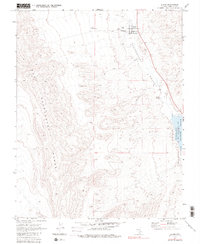
1980 Map of Alamo
USGS Topo · Published 1989About this map
Alamo serves as the primary hub of this high-desert landscape, situated within the Pahranagat Valley between the arid reaches of the East Pahranagat Range. The map reveals a community structured around both agriculture and local services, featuring the Pahranagat Valley Sch, Rodeo Grounds, and the Alamo Landing Field. Water remains the central organizing principle for settlement in this Great Basin environment, evidenced by the presence of Grove Spring and the Upper Pahranagat Lake within the Pahranagat National Wildlife Refuge. Beyond the town center, the landscape is marked by historical traces such as Ruins and a lone Prospect, while a network of Jeep Trails and ranch sites like Buckhorn Ranch extend into the surrounding hills, illustrating the enduring relationship between isolated homesteading and the desert terrain.
Find a feature on this map
16 named features on this map. Tap any name to fly to it.
Don’t see what you’re looking for? This feature index may not catch every label — zoom into the map to look around manually.
Map Details
Editions of this 1980 Alamo Map
This is the sole edition of this map. No revisions or reprints were ever made.
Other maps of this area

1945 · Alamo
USGS Topo · 1:125,000

1954 · Caliente
USGS Topo · 1:250,000

1959 · Caliente
USGS Topo · 1:250,000

1969 · Alamo SE
USGS Topo · 1:24,000

1969 · Lower Pahranagat Lake
USGS Topo · 1:24,000

1969 · Alamo NE
USGS Topo · 1:24,000
1969 · Lower Pahranagat Lake NW
USGS Topo · 1:24,000

1969 · Alamo
USGS Topo · 1:24,000

1969 · Ash Springs
USGS Topo · 1:24,000
1980 · Alamo SE
USGS Topo · 1:24,000