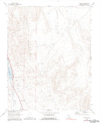
1980 Map of Alamo SE
USGS Topo · Published 1992About this map
Pahranagat National Wildlife Refuge dominates the western edge of this landscape, centered on the Upper Pahranagat Lake with its spillway recorded at an elevation of 3351 feet. The map captures the administrative and logistical infrastructure of the refuge, including the Refuge Hdqrs and a nearby Gravel Pit. To the east, the terrain rises sharply into the Hiko Range, a series of ridges that overlook the broad expanse of Eightmile Valley. This 1980 photoinspection reveals a classic Great Basin environment where water management at the lake is contrasted by the arid, undeveloped reaches of the surrounding desert mountains. Transportation is focused on the corridor along Highway 93, which provides the primary access through the Pahranagat Valley.
Find a feature on this map
8 named features on this map. Tap any name to fly to it.
Don’t see what you’re looking for? This feature index may not catch every label — zoom into the map to look around manually.
Map Details
Editions of this 1980 Alamo SE Map
This is the sole edition of this map. No revisions or reprints were ever made.
Other maps of this area

1885 · Pioche
USGS Topo · 1:250,000

1886 · Pioche
USGS Topo · 1:250,000

1945 · Alamo
USGS Topo · 1:125,000

1954 · Caliente
USGS Topo · 1:250,000

1959 · Caliente
USGS Topo · 1:250,000

1969 · Alamo SE
USGS Topo · 1:24,000

1969 · Lower Pahranagat Lake
USGS Topo · 1:24,000

1969 · Alamo NE
USGS Topo · 1:24,000
1969 · Lower Pahranagat Lake NW
USGS Topo · 1:24,000
1969 · Delamar 3 NW
USGS Topo · 1:24,000