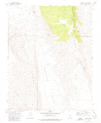
1969 Map of Alamo NE
USGS Topo · Published 1980About this map
South Pahroc Range and the Hiko Range dominate this desert landscape in Lincoln County, Nevada, as it appeared in the late 1960s. The topography is defined by the high, wooded elevations of the South Pahroc Range and the lower, fractured ridges of the Hiko Range, with Eightmile Valley serving as the central drainage between these mountainous blocks. Water sources are scarce and localized, represented by isolated points like Sixmile Spring, Eightmile Spring, and Twin Springs.
Find a feature on this map
10 named features on this map. Tap any name to fly to it.
Don’t see what you’re looking for? This feature index may not catch every label — zoom into the map to look around manually.
Map Details
Editions of this 1969 Alamo NE Map
2 editions found
Other maps of this area

1885 · Pioche
USGS Topo · 1:250,000

1886 · Pioche
USGS Topo · 1:250,000

1945 · Alamo
USGS Topo · 1:125,000

1954 · Caliente
USGS Topo · 1:250,000

1959 · Caliente
USGS Topo · 1:250,000

1969 · Alamo SE
USGS Topo · 1:24,000

1969 · Alamo NE
USGS Topo · 1:24,000

1969 · Alamo
USGS Topo · 1:24,000

1969 · Delamar NW
USGS Topo · 1:24,000

1969 · Ash Springs
USGS Topo · 1:24,000