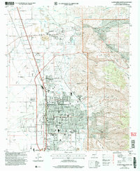
2004 Map of Alamogordo North
USGS Topo · Published 2006About this map
Alamogordo and the historic village of La Luz are documented here during a period of significant urban development at the turn of the 21st century. The map illustrates a dense network of local schools and civic landmarks, ranging from the NM School for the Blind and Visually Impaired to the New Mexico Museum of Space History. To the east, the terrain rises sharply into the Lincoln National Forest, where steep canyons like Fresnal Canyon and Dry Canyon provide a sharp contrast to the systematic grid of the city. The influence of regional infrastructure is evident in the inclusion of the Otero County Fairground, the New Mexico State University (Alamogordo Branch), and the northern fringes of Holloman Air Force Base. Tracing the Standard Parallel South and the Aqueduct, one can see how water management and federal land boundaries have shaped the growth of this desert community.
Find a feature on this map
48 named features on this map. Tap any name to fly to it.
Don’t see what you’re looking for? This feature index may not catch every label — zoom into the map to look around manually.
Map Details
Editions of this 2004 Alamogordo North Map
This is the sole edition of this map. No revisions or reprints were ever made.
Other maps of this area

1916 · Tularosa
USGS Topo · 1:125,000

1916 · Point Of Sands
USGS Topo · 1:125,000

1948 · Tularosa
USGS Topo · 1:62,500

1948 · Holloman
USGS Topo · 1:62,500

1950 · Alamogordo
USGS Topo · 1:62,500

1950 · Mescalero
USGS Topo · 1:62,500

1954 · Carlsbad
USGS Topo · 1:250,000

1954 · Tularosa
USGS Topo · 1:250,000

1955 · Las Cruces
USGS Topo · 1:250,000

1955 · Roswell
USGS Topo · 1:250,000