
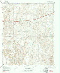
1963 Map of Alanreed
USGS Topo · Published 1967About this map
Alanreed stands as a focal point in the Texas Panhandle during the early 1960s, situated at a major crossroads of transportation. The town is tied to the path of the Chicago Rock Island and Pacific railroad and the historic Route 66, reflecting its importance for transcontinental travel and local commerce. Beyond the town center, the Alanreed Cem and a nearby Gravel Pit mark the human presence and industry on the landscape.
Find a feature on this map
18 named features on this map. Tap any name to fly to it.
Don’t see what you’re looking for? This feature index may not catch every label — zoom into the map to look around manually.
Map Details
Editions of this 1963 Alanreed Map
2 editions found
Other maps of this area

1954 · Amarillo
USGS Topo · 1:250,000

1958 · Amarillo
USGS Topo · 1:250,000

1959 · Troublesome Creek
USGS Topo · 1:24,000

1959 · Spencer Lake
USGS Topo · 1:24,000

1962 · Griffin Ranch
USGS Topo · 1:24,000

1962 · Hudgens Ranch
USGS Topo · 1:24,000

1962 · Back
USGS Topo · 1:24,000

1963 · McLean
USGS Topo · 1:24,000

1964 · Rockledge
USGS Topo · 1:24,000

1968 · Taylor Ranch
USGS Topo · 1:24,000