
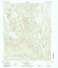
1962 Map of Griffin Ranch
USGS Topo · Published 1963About this map
Griffin Ranch and its satellite operations, Griffin North Ranch and Griffin East Ranch, define the settlement patterns of this ranching landscape in Donley County. The terrain is characterized by the erosive drainages flowing south toward the Salt Fork Red River, which cuts across the southern portion of the quadrangle. Significant water sources for livestock and local habitation are noted through labels for Spring and Springs found along the creek beds. Transport in the early 1960s was limited, with a prominent Jeep Trail winding through the western hills. The map also records Mc Murtry and several named waterways such as Saddlers Creek and Turkey Creek, which reveal the historical importance of water access in this arid part of the Texas Panhandle.
Find a feature on this map
14 named features on this map. Tap any name to fly to it.
Don’t see what you’re looking for? This feature index may not catch every label — zoom into the map to look around manually.
Map Details
Editions of this 1962 Griffin Ranch Map
2 editions found
Other maps of this area

1954 · Amarillo
USGS Topo · 1:250,000

1954 · Plainview
USGS Topo · 1:250,000

1958 · Amarillo
USGS Topo · 1:250,000

1958 · Plainview
USGS Topo · 1:250,000

1959 · Lelia Lake Creek
USGS Topo · 1:24,000

1959 · Troublesome Creek
USGS Topo · 1:24,000

1962 · Lelia Lake
USGS Topo · 1:24,000

1962 · Roach Ranch
USGS Topo · 1:24,000

1963 · Clarendon
USGS Topo · 1:24,000

1963 · Alanreed
USGS Topo · 1:24,000