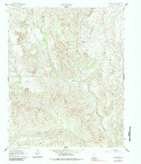
1962 Map of Griffin Ranch
USGS Topo · Published 1984About this map
Griffin Ranch and its associated outposts, Griffin North Ranch and Griffin East Ranch, define the mid-century cattle ranching operations of this Donley County landscape. Situated along the Salt Fork Red River, the topography is carved by a network of drainage systems including Barton Creek, Saddlers Creek, and Turkey Creek. The map reveals a highly functional working landscape, where numerous unnamed Spring and Springs provide critical water sources in the dry Texas panhandle. Transport in this period is dominated by a rugged Jeep Trail and unimproved dirt roads that connect the ranch headquarters with the small settlement at McMurtry. The survey detail captures the region before extensive modern development, highlighting the intersection of hydrography and high-plains ranching life.
Find a feature on this map
14 named features on this map. Tap any name to fly to it.
Don’t see what you’re looking for? This feature index may not catch every label — zoom into the map to look around manually.
Map Details
Editions of this 1962 Griffin Ranch Map
2 editions found
Other maps of this area

1954 · Amarillo
USGS Topo · 1:250,000

1954 · Plainview
USGS Topo · 1:250,000

1958 · Amarillo
USGS Topo · 1:250,000

1958 · Plainview
USGS Topo · 1:250,000

1959 · Lelia Lake Creek
USGS Topo · 1:24,000

1959 · Troublesome Creek
USGS Topo · 1:24,000

1962 · Lelia Lake
USGS Topo · 1:24,000

1962 · Roach Ranch
USGS Topo · 1:24,000

1962 · Griffin Ranch
USGS Topo · 1:24,000

1963 · Clarendon
USGS Topo · 1:24,000