
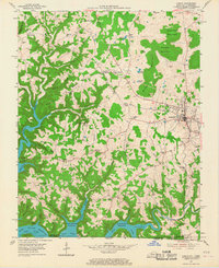
1954 Map of Albany
USGS Topo · Published 1955About this map
Albany serves as the focal point of this Clinton County landscape, situated where the terrain transitions from the elevations of Grider Mountain and Burchett Mountain down toward the winding waters of the Wolf River. The 1950s rural infrastructure is recorded here in great detail, showing a high density of one-room schoolhouses such as Highway Sch, Snow Sch, and Mt Vernon Sch that once served these dispersed upland communities. To the south and west, the map documents the shoreline of the Dale Hollow Reservoir, where the rising waters filled the deep valleys of Sulphur Creek and Illwill Creek. Small crossroads settlements like Ootens Store and Wago anchor the northern reaches, while the southern border traces the Kentucky-Tennessee state line near Huntersville, providing a precise look at the mid-century road network and the family-named cemeteries that dot the ridges.
Find a feature on this map
61 named features on this map. Tap any name to fly to it.
Don’t see what you’re looking for? This feature index may not catch every label — zoom into the map to look around manually.
Map Details
Editions of this 1954 Albany Map
2 editions found
Other maps of this area

1924 · Lillydale
USGS Topo · 1:62,500

1926 · Lillydale
USGS Topo · 1:62,500

1929 · Lillydale
USGS Topo · 1:62,500

1929 · Byrdstown
USGS Topo · 1:62,500

1953 · Burkesville
USGS Topo · 1:24,000

1953 · Wolf Creek Dam
USGS Topo · 1:24,000

1954 · Frogue
USGS Topo · 1:24,000

1954 · Cumberland City
USGS Topo · 1:24,000

1954 · Savage
USGS Topo · 1:24,000

1956 · Corbin
USGS Topo · 1:250,000