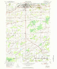
1950 Map of Albion
USGS Topo · Published 1985About this map
The Erie Canal corridor defines the northern edge of this Orleans County landscape, where the village of Albion serves as a regional hub for transportation and institutional life. The canal, paralleled by the New York Central railroad, supports a dense network of civic features including the State Training School for Girls, the County Fairgrounds, and the County Hospital. South of the canal, the terrain transitions into the agricultural heartland of Barre, characterized by a grid of rural roads like Telegraph Road and Allen Road.
Find a feature on this map
47 named features on this map. Tap any name to fly to it.
Don’t see what you’re looking for? This feature index may not catch every label — zoom into the map to look around manually.
Map Details
Editions of this 1950 Albion Map
3 editions found
Other maps of this area

1897 · Albion
USGS Topo · 1:62,500

1897 · Medina
USGS Topo · 1:62,500

1897 · Oak Orchard
USGS Topo · 1:62,500

1897 · Ridgeway
USGS Topo · 1:62,500

1944 · Holley
USGS Topo · 1:31,680

1944 · Byron
USGS Topo · 1:31,680

1944 · Ashwood
USGS Topo · 1:31,680

1944 · Albion
USGS Topo · 1:31,680

1949 · Kendall
USGS Topo · 1:62,500
1950 · Knowlesville
USGS Topo · 1:24,000