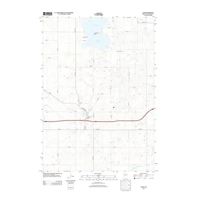
2013 Map of Alden
USGS Topo · Published 2013About this map
Alden anchors this southern Minnesota landscape, situated at the intersection of local routes like Washington Ave and S Broadway. The town's layout is centered around Morin Lake and the local Post Office, serving as a primary hub for the surrounding agricultural district. To the north, the terrain is dominated by the sprawling Freeborn Lake, featuring distinctive geographic landmarks such as Chicks Point and Arrowhead Point. The hydrography of the region is defined by a network of natural and engineered waterways, including the Cobb River and various drainage systems like County Ditch Number Fiftyfour.
Find a feature on this map
41 named features on this map. Tap any name to fly to it.
Don’t see what you’re looking for? This feature index may not catch every label — zoom into the map to look around manually.
Map Details
Editions of this 2013 Alden Map
This is the sole edition of this map. No revisions or reprints were ever made.
Other maps of this area

1954 · Albert Lea
USGS Topo · 1:62,500

1954 · Mason City
USGS Topo · 1:250,000

1955 · Wells
USGS Topo · 1:62,500

1957 · Mason City
USGS Topo · 1:250,000

1958 · Mason City
USGS Topo · 1:250,000

1967 · Freeborn
USGS Topo · 1:24,000
1967 · Matawan
USGS Topo · 1:24,000

1967 · Hartland
USGS Topo · 1:24,000

1982 · Albert Lea West
USGS Topo · 1:24,000
1982 · Emmons
USGS Topo · 1:24,000