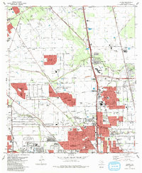
1982 Map of Aldine
USGS Topo · Published 1983About this map
The Bammel Oil and Gas Field dominates the northern reaches of this Harris County survey, where a dense network of pipelines and gas wells intermingles with the suburban expansion of northern Houston. This era of development is marked by large-scale residential tracts like Rushwood, Fallbrook, and Woodgate pushing into former agricultural and industrial lands. Significant civic landmarks such as the Houston National Cemetery and Resthaven Memorial Gardens occupy large footprints, while the Collier Airport and Inwood Forest Country Club reflect the regional land use before further urbanization. The hydrological character of the area is defined by the winding paths of Greens Bayou and Halls Bayou, which provided natural drainage for the burgeoning suburban landscape. This map captures the transition from an energy-driven rural economy to a modern metropolitan corridor along the Missouri Pacific railroad line and the North Belt Drive.
Find a feature on this map
64 named features on this map. Tap any name to fly to it.
Don’t see what you’re looking for? This feature index may not catch every label — zoom into the map to look around manually.
Map Details
Editions of this 1982 Aldine Map
2 editions found
Other maps of this area

1915 · Houston Heights
USGS Topo · 1:24,000

1915 · Hillendahl
USGS Topo · 1:24,000

1916 · Aldine
USGS Topo · 1:24,000

1916 · Settegast
USGS Topo · 1:24,000

1916 · Louetta
USGS Topo · 1:24,000

1916 · Satsuma
USGS Topo · 1:24,000

1916 · Humble
USGS Topo · 1:24,000

1916 · Spring
USGS Topo · 1:24,000

1918 · Hillendahl
USGS Topo · 1:31,680

1919 · Aldine
USGS Topo · 1:31,680