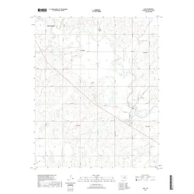
2018 Map of Alex
USGS Topo · Published 2018About this map
The Washita River and its numerous tributaries, including the Little Washita River and Bitter Creek, dominate this part of Grady County. The settlement of Alex serves as a central point in the southeastern quadrant, where local landmarks like the Ireton Cem and Alex Cem provide valuable touchpoints for genealogists. The landscape is structured by a grid of county roads such as Co RD 1440 and Cedar Hill Rd, which connect rural properties and regional aviation sites like Fulton Airport and the Drifting G Ranch Airport. North of the river, a portion of Chickasha is visible, showing the reach of the county seat. This 2018 survey reveals a modern agricultural and ranching corridor defined by the serpentine path of the river and the creeks that feed into it, such as Winter Cr and Soldier Cr.
Find a feature on this map
69 named features on this map. Tap any name to fly to it.
Don’t see what you’re looking for? This feature index may not catch every label — zoom into the map to look around manually.
Map Details
Editions of this 2018 Alex Map
This is the sole edition of this map. No revisions or reprints were ever made.
Other maps of this area

1902 · Rush Springs
USGS Topo · 1:125,000

1904 · Chickasha
USGS Topo · 1:125,000

1949 · Rush Springs
USGS Topo · 1:62,500

1950 · Rush Springs
USGS Topo · 1:62,500

1954 · Oklahoma City
USGS Topo · 1:250,000

1957 · Ardmore
USGS Topo · 1:250,000

1957 · Oklahoma City
USGS Topo · 1:250,000

1963 · Ardmore
USGS Topo · 1:250,000

1963 · Oklahoma City
USGS Topo · 1:250,000
1965 · Dibble
USGS Topo · 1:24,000