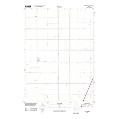
2010 Map of Alexander
USGS Topo · Published 2010About this map
Alexander forms the primary hub of this agricultural landscape in Franklin County, characterized by a highly organized section-line road grid. The town is marked by its essential civic services, including the Alexander Post Office and the nearby Alexander Cemetery. Further north, Holland Cemetery serves as another focal point for family researchers tracing the area's rural heritage. This 2010 survey reflects a modern prairie drainage system, where natural watercourses like Otter Creek and Buffalo Creek are supplemented by man-made infrastructure such as Ditch Number 146. The landscape is dominated by large-scale farming, evidenced by the regular intervals of roads like Cardinal Ave and Dogwood Ave that facilitate access across this portion of northern Iowa.
Find a feature on this map
22 named features on this map. Tap any name to fly to it.
Don’t see what you’re looking for? This feature index may not catch every label — zoom into the map to look around manually.
Map Details
Editions of this 2010 Alexander Map
This is the sole edition of this map. No revisions or reprints were ever made.
Other maps of this area

1954 · Waterloo
USGS Topo · 1:250,000

1955 · Waterloo
USGS Topo · 1:250,000

1972 · Alexander
USGS Topo · 1:24,000

1972 · Thornton
USGS Topo · 1:24,000

1972 · Swaledale
USGS Topo · 1:24,000

1972 · Belmond
USGS Topo · 1:24,000

1972 · Latimer
USGS Topo · 1:24,000
1972 · Goodell
USGS Topo · 1:24,000

1978 · Dows West
USGS Topo · 1:24,000

1979 · Dows East
USGS Topo · 1:24,000