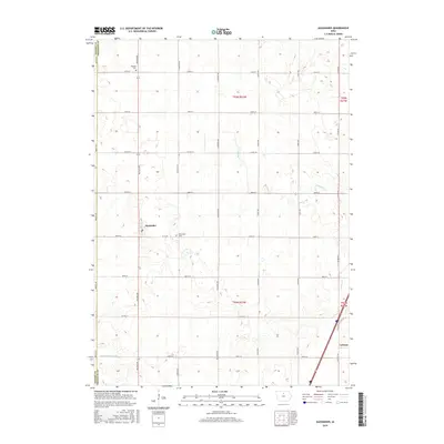
2015 Map of Alexander
USGS Topo · Published 2015About this map
Alexander and Latimer anchor this portion of the northern Iowa prairie, where the landscape is defined by the rigid geometry of the Public Land Survey System. The boundary between Wright Co and Franklin Co runs vertically along the western edge, marked by Wright Ave. While the region is primarily agricultural, the presence of Holland Cem near the northern border and Alexander Cem just east of town provides important touchstones for genealogical research. Natural drainage is subtle here, consisting of the meandering Buffalo Cr and Spring Cr, supplemented by man-made alterations like Ditch Number 146. This network of section-line roads, such as Balsam Ave and Dogwood Ave, illustrates the systematic organization of the rural Midwest during the mid-2010s.
Find a feature on this map
30 named features on this map. Tap any name to fly to it.
Don’t see what you’re looking for? This feature index may not catch every label — zoom into the map to look around manually.
Map Details
Editions of this 2015 Alexander Map
This is the sole edition of this map. No revisions or reprints were ever made.
Other maps of this area

1954 · Waterloo
USGS Topo · 1:250,000

1955 · Waterloo
USGS Topo · 1:250,000

1972 · Alexander
USGS Topo · 1:24,000

1972 · Thornton
USGS Topo · 1:24,000

1972 · Swaledale
USGS Topo · 1:24,000

1972 · Belmond
USGS Topo · 1:24,000

1972 · Latimer
USGS Topo · 1:24,000
1972 · Goodell
USGS Topo · 1:24,000

1978 · Dows West
USGS Topo · 1:24,000

1979 · Dows East
USGS Topo · 1:24,000