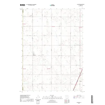
2018 Map of Alexander
USGS Topo · Published 2018About this map
Alexander and Latimer anchor this rural landscape in Franklin County, where a highly structured grid of farm-to-market roads defines the Iowa prairie. The map shows the border between Wright County and Franklin County, marked by Wright Ave on the western edge. This 2018 survey reveals a terrain engineered for agriculture, characterized by numerous small depressions and the presence of Ditch Number 146, indicating the extensive land-drainage efforts typical of this region. Local history is anchored by the Holland Cem in the north and the Alexander Cem just outside its namesake town. Natural drainage is still visible through the meandering paths of Buffalo Cr and Spring Cr, which contrast with the rigid lines of the surrounding section roads and county routes like Co Rd C23.
Find a feature on this map
32 named features on this map. Tap any name to fly to it.
Don’t see what you’re looking for? This feature index may not catch every label — zoom into the map to look around manually.
Map Details
Editions of this 2018 Alexander Map
This is the sole edition of this map. No revisions or reprints were ever made.
Other maps of this area

1954 · Waterloo
USGS Topo · 1:250,000

1955 · Waterloo
USGS Topo · 1:250,000

1972 · Alexander
USGS Topo · 1:24,000

1972 · Thornton
USGS Topo · 1:24,000

1972 · Swaledale
USGS Topo · 1:24,000

1972 · Belmond
USGS Topo · 1:24,000

1972 · Latimer
USGS Topo · 1:24,000
1972 · Goodell
USGS Topo · 1:24,000

1978 · Dows West
USGS Topo · 1:24,000

1979 · Dows East
USGS Topo · 1:24,000