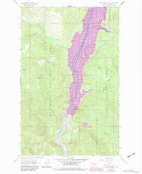
1963 Map of Alexander Mountain
USGS Topo · Published 1984About this map
Libby Dam dominates this 1963 survey of the Montana high country, revised in the early 1980s to show the dramatic transformation of the Kootenai River valley. The construction of the dam created the massive Lake Koocanusa, a reservoir that redefined the local geography by submerging former riverbanks and creating new features like Yarnell Island and the Kootenai Narrows. The purple photorevision markings highlight the development of recreational infrastructure following the dam's completion, including the Cripple Horse Marina and multiple boat ramps.
Find a feature on this map
31 named features on this map. Tap any name to fly to it.
Don’t see what you’re looking for? This feature index may not catch every label — zoom into the map to look around manually.
Map Details
Editions of this 1963 Alexander Mountain Map
2 editions found
Other maps of this area

1920 · Jennings
USGS Topo · 1:125,000

1935 · Thompson Lakes
USGS Topo · 1:96,000

1942 · Thompson Lakes
USGS Topo · 1:125,000

1957 · Kalispell
USGS Topo · 1:250,000

1960 · Kalispell
USGS Topo · 1:250,000

1961 · Kalispell
USGS Topo · 1:250,000

1963 · Vermiculite Mountain
USGS Topo · 1:24,000

1963 · Swede Mountain
USGS Topo · 1:24,000

1963 · Banfield Mountain
USGS Topo · 1:24,000

1963 · Cripple Horse Mountain
USGS Topo · 1:24,000