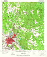
1957 Map of Alexandria
USGS Topo · Published 1965About this map
The Red River corridor defines this 1950s survey, separating the urban centers of Alexandria and Pineville from the sprawling woodlands of the Kisatchie National Forest. The map documents a period of significant institutional and military presence in Central Louisiana, centered on the extensive grounds of Camp Beauregard and the Central Louisiana State Hospital. In Alexandria, the landscape is a grid of mid-century growth, featuring numerous local landmarks like Peabody High Sch and the MacArthur Dr Airport.
Find a feature on this map
105 named features on this map. Tap any name to fly to it.
Don’t see what you’re looking for? This feature index may not catch every label — zoom into the map to look around manually.
Map Details
Editions of this 1957 Alexandria Map
2 editions found

Other maps of this area

1932 · Boyce NE
USGS Topo · 1:31,680

1932 · Colfax SE
USGS Topo · 1:31,680

1935 · Lecompte
USGS Topo · 1:62,500

1936 · Colfax
USGS Topo · 1:62,500

1936 · Pollock
USGS Topo · 1:62,500

1940 · Marksville
USGS Topo · 1:62,500

1941 · Jena
USGS Topo · 1:62,500

1941 · Alexandria
USGS Topo · 1:62,500

1941 · Buckeye
USGS Topo · 1:62,500

1941 · Pollock
USGS Topo · 1:62,500