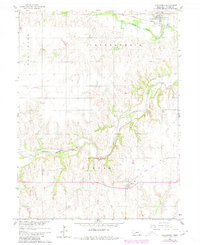
1960 Map of Alexandria
USGS Topo · Published 1980About this map
The village of Alexandria sits at the junction of the Union Pacific railroad and Big Sandy Creek in Thayer County, Nebraska. This 1960 survey, updated in 1980, captures the agricultural landscape and rural infrastructure of the Missouri River Basin during a period of shifting transportation. A significant Old Railroad Grade meanders through the township of Gilead, following the contours of the Little Blue River, marking the location of a decommissioned line that once served the local grain economy. Genealogy researchers will find several well-defined burial grounds, including Alexandria Cem, St Marys Cem, and Union Cem. The map also records the location of rural education at School No 25 and industrial activity at a Quarry, providing a clear picture of the community centers and land use that defined this part of the Nebraska plains.
Find a feature on this map
15 named features on this map. Tap any name to fly to it.
Don’t see what you’re looking for? This feature index may not catch every label — zoom into the map to look around manually.
Map Details
Editions of this 1960 Alexandria Map
2 editions found
Other maps of this area

1898 · Hebron
USGS Topo · 1:125,000

1955 · Lincoln
USGS Topo · 1:250,000

1957 · Lincoln
USGS Topo · 1:250,000

1958 · Lincoln
USGS Topo · 1:250,000

1960 · Bruning
USGS Topo · 1:24,000

1960 · Chester
USGS Topo · 1:24,000

1960 · Reynolds
USGS Topo · 1:24,000

1960 · Hubbell
USGS Topo · 1:24,000

1960 · Tobias SW
USGS Topo · 1:24,000

1960 · Alexandria
USGS Topo · 1:24,000