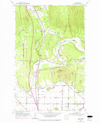
1952 Map of Alger
USGS Topo · Published 1977About this map
Alger serves as a central hub in this Skagit County landscape, where the confluence of Friday Creek and Silver Lake meets the foothills of Anderson Mtn. The 1952 topography, with 1968 revisions, reveals a community built around natural resources and local infrastructure, featuring the State Salmon Hatchery and several gravel operations. The rail corridor of the Great Northern cuts through the western edge of the quadrangle, passing near the Belfast Sch (Aban'd), while the rural east is defined by open spaces like German Prairie and Warner Prairie. Local social life is anchored by landmarks such as the Silver Run Grange and Hickson Community Hall. This survey captures the transition from a purely agricultural and logging-oriented economy to a more diversified landscape, including the recreational space at Donovan State Park and the curious settlement of Garden of Eden tucked near Wollard Creek.
Find a feature on this map
48 named features on this map. Tap any name to fly to it.
Don’t see what you’re looking for? This feature index may not catch every label — zoom into the map to look around manually.
Map Details
Editions of this 1952 Alger Map
4 editions found
Other maps of this area

1911 · Mount Vernon
USGS Topo · 1:125,000

1918 · Samish Lake
USGS Topo · 1:62,500

1921 · Wickersham
USGS Topo · 1:62,500

1940 · Mt Vernon
USGS Topo · 1:62,500

1943 · Mt Vernon
USGS Topo · 1:62,500

1944 · Clear Lake
USGS Topo · 1:62,500

1951 · Wickersham
USGS Topo · 1:62,500

1952 · Lake Whatcom
USGS Topo · 1:24,000

1952 · Alger
USGS Topo · 1:24,000

1954 · Bow
USGS Topo · 1:24,000