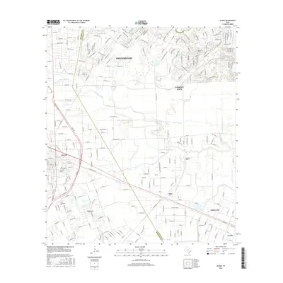
2016 Map of Algoa
USGS Topo · Published 2016About this map
Dickinson Bayou and Mustang Bayou meander through this coastal Texas landscape, marking the transition between the urban expansion of Friendswood and League City and the more dispersed rural settlements to the south. The map documents the intricate network of suburban developments north of the Brazoria and Galveston county line, contrasting with the open agricultural fields and scattered farmstead road grids around Algoa and Arcadia. Infrastructure for water management and transit is prominent, with the American Canal cutting across the northwestern corner and the presence of the Kami-Kazi Airport near the center. Local institutional history is anchored by the Alvin Community College campus and the historic Magnolia Cem, reflecting the region's steady growth and established communities in the mid-2010s.
Find a feature on this map
252 named features on this map. Tap any name to fly to it.
Don’t see what you’re looking for? This feature index may not catch every label — zoom into the map to look around manually.
Map Details
Editions of this 2016 Algoa Map
This is the sole edition of this map. No revisions or reprints were ever made.
Other maps of this area

1916 · Genoa
USGS Topo · 1:24,000

1916 · Seabrook
USGS Topo · 1:24,000

1920 · Seabrook
USGS Topo · 1:31,680

1920 · Genoa
USGS Topo · 1:31,680

1920 · Mykawa
USGS Topo · 1:31,680

1929 · Dickinson
USGS Topo · 1:24,000

1929 · Algoa
USGS Topo · 1:24,000

1929 · Hitchcock
USGS Topo · 1:24,000

1932 · Algoa
USGS Topo · 1:31,680
1932 · Genoa
USGS Topo · 1:31,680