
1929 Map of Algoa
USGS Topo · Published 1929About this map
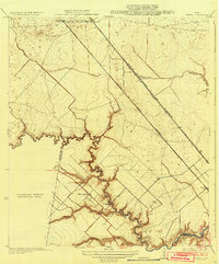
Algoa sits at the nexus of the coastal prairie and the industrializing rail corridors of the late 1920s. This survey, conducted under the direction of County Engineer C. C. Washington and Division Engineer H. H. Hodgeson, documents a landscape defined by its drainage and early resource extraction. The meandering path of Dickinson Bayou and the seasonal waters of Chigger Creek dictate the local topography, while the Gulf Colorado and Santa Fe railroad provides the vital transit link for this agricultural community. A distinctive geological notation on this sheet includes several Gas Bumps, signaling the subterranean activities of the Gulf Coast salt dome region during a period of expanding petroleum exploration. The boundary between Brazoria and Galveston Counties bisects the western portion of the quadrangle, illustrating how these political lines intersected with the natural watersheds of Clear Cr.
Find a feature on this map
8 named features on this map. Tap any name to fly to it.
Don’t see what you’re looking for? This feature index may not catch every label — zoom into the map to look around manually.
Map Details
Editions of this 1929 Algoa Map
This is the sole edition of this map. No revisions or reprints were ever made.
Other maps of this area

1916 · Genoa
USGS Topo · 1:24,000

1916 · Seabrook
USGS Topo · 1:24,000

1920 · Seabrook
USGS Topo · 1:31,680

1920 · Genoa
USGS Topo · 1:31,680

1920 · Mykawa
USGS Topo · 1:31,680

1929 · Dickinson
USGS Topo · 1:24,000

1929 · Hitchcock
USGS Topo · 1:24,000

1932 · Algoa
USGS Topo · 1:31,680
1932 · Genoa
USGS Topo · 1:31,680

1932 · Dickinson
USGS Topo · 1:31,680