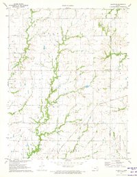
1971 Map of Aliceville
USGS Topo · Published 1973About this map
Aliceville anchors this eastern Kansas landscape, situated where the Missouri Pacific line cuts through the agricultural heart of Spring Creek and Avon townships. This 1971 survey captures the rural layout of the region, defined by a dense network of small family and community burial grounds that reflect the area's deep genealogical roots. From the northern reaches near Star Cem and Scott Valley Ch down to Quisling Cem in the south, these landmarks provide specific anchor points for local history researchers.
Find a feature on this map
23 named features on this map. Tap any name to fly to it.
Don’t see what you’re looking for? This feature index may not catch every label — zoom into the map to look around manually.
Map Details
Editions of this 1971 Aliceville Map
2 editions found
Other maps of this area

1885 · Burlington
USGS Topo · 1:125,000

1885 · Garnett
USGS Topo · 1:125,000

1894 · Garnett
USGS Topo · 1:125,000

1894 · Burlington
USGS Topo · 1:125,000

1947 · Lawrence
USGS Topo · 1:250,000

1950 · Lawrence
USGS Topo · 1:250,000

1956 · Lawrence
USGS Topo · 1:250,000

1961 · Lawrence
USGS Topo · 1:250,000
1966 · Westphalia
USGS Topo · 1:24,000
1966 · Harris
USGS Topo · 1:24,000