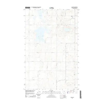
2014 Map of Alkabo
USGS Topo · Published 2014About this map
Alkabo sits in the corner of this Divide County landscape, positioned within a high prairie environment defined by seasonal wetlands and glacial depressions. This 2014 survey captures the township's rural character, where large water bodies like North Lake and Miller Lake punctuate the grid of gravel section roads. The map provides clear evidence of the area's social history through the preservation of local burial grounds, specifically Hillcrest Cem in the southern reaches and Skabo Cem near the southeastern border. The transportation network is anchored by several county routes, including CR-5 and CR-3, which link isolated farmsteads across the undulating terrain. The pattern of development here reflects the enduring agricultural heritage of the far northwestern corner of the state, where the land is carved into precise sections but remains dominated by its natural hydrology.
Find a feature on this map
21 named features on this map. Tap any name to fly to it.
Don’t see what you’re looking for? This feature index may not catch every label — zoom into the map to look around manually.
Map Details
Editions of this 2014 Alkabo Map
This is the sole edition of this map. No revisions or reprints were ever made.
Other maps of this area

1953 · Williston
USGS Topo · 1:250,000

1954 · Wolf Point
USGS Topo · 1:250,000

1957 · Williston
USGS Topo · 1:250,000

1958 · Wolf Point
USGS Topo · 1:250,000

1983 · Westby South
USGS Topo · 1:24,000

1983 · Writing Rock North
USGS Topo · 1:24,000

1983 · Alkabo
USGS Topo · 1:24,000

1983 · Westby North
USGS Topo · 1:24,000

1983 · Writing Rock South
USGS Topo · 1:24,000
1983 · Fortuna
USGS Topo · 1:24,000