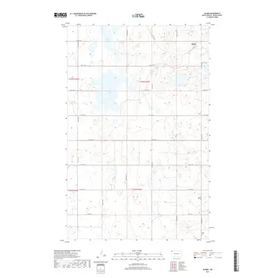
2017 Map of Alkabo
USGS Topo · Published 2017About this map
Alkabo sits in the northern reaches of this Divide County landscape, surrounded by the characteristic prairie pothole topography of the High Plains. The terrain is defined by numerous small depressions and larger water bodies like North Lake and Miller Lake, which dominate the central and northern sections of the township. The regular section-line road grid, including 150th Ave NW and 98th St NW, imposes a geometric order on the varied wetlands. For local history researchers, the map provides precise locations for family and community sites, most notably Hillcrest Cem and Skabo Cem in the southeastern quadrant. These cemeteries serve as enduring markers of the early 20th-century homesteading era in a region where the vast majority of the land remains dedicated to large-scale agriculture.
Find a feature on this map
23 named features on this map. Tap any name to fly to it.
Don’t see what you’re looking for? This feature index may not catch every label — zoom into the map to look around manually.
Map Details
Editions of this 2017 Alkabo Map
This is the sole edition of this map. No revisions or reprints were ever made.
Other maps of this area

1953 · Williston
USGS Topo · 1:250,000

1954 · Wolf Point
USGS Topo · 1:250,000

1957 · Williston
USGS Topo · 1:250,000

1958 · Wolf Point
USGS Topo · 1:250,000

1983 · Westby South
USGS Topo · 1:24,000

1983 · Writing Rock North
USGS Topo · 1:24,000

1983 · Alkabo
USGS Topo · 1:24,000

1983 · Westby North
USGS Topo · 1:24,000

1983 · Writing Rock South
USGS Topo · 1:24,000
1983 · Fortuna
USGS Topo · 1:24,000