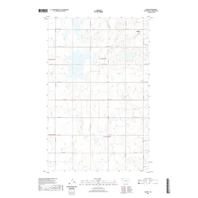
2020 Map of Alkabo
USGS Topo · Published 2020About this map
Alkabo sits in the northeastern reaches of this Divide County landscape, positioned at a junction of rural roads including Co 5 and Co 3. The terrain is defined by the heavy presence of prairie potholes and seasonal wetlands, with North Lake and Miller Lake serving as the primary permanent water bodies. These features suggest a high-plains environment where drainage is largely internal, creating a mosaic of small depressions across the glacial till. For family historians and researchers, the map identifies two significant burial sites: Hillcrest Cem near the eastern boundary and Skabo Cem to the southeast. The rigid grid of the Public Land Survey System, marked by township boundaries like t162n r102w and t161n r102w, dictates the placement of the county's gravel roads and agricultural sections, illustrating the late-modern spatial organization of this North Dakota borderland.
Find a feature on this map
25 named features on this map. Tap any name to fly to it.
Don’t see what you’re looking for? This feature index may not catch every label — zoom into the map to look around manually.
Map Details
Editions of this 2020 Alkabo Map
This is the sole edition of this map. No revisions or reprints were ever made.
Other maps of this area

1953 · Williston
USGS Topo · 1:250,000

1954 · Wolf Point
USGS Topo · 1:250,000

1957 · Williston
USGS Topo · 1:250,000

1958 · Wolf Point
USGS Topo · 1:250,000

1983 · Westby South
USGS Topo · 1:24,000

1983 · Writing Rock North
USGS Topo · 1:24,000

1983 · Alkabo
USGS Topo · 1:24,000

1983 · Westby North
USGS Topo · 1:24,000

1983 · Writing Rock South
USGS Topo · 1:24,000
1983 · Fortuna
USGS Topo · 1:24,000