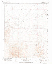
1970 Map of Alkali
USGS Topo · Published 1973About this map
Alkali stands as a lonely point of reference in the high desert of Esmeralda County, situated near the Alkali Hot Spring and the expansive Alkali Lake Alkali Flat (Depression). This 1970 survey captures a landscape defined by the intersection of early mining history and the harsh geography of the Great Basin. To the south, the Montezuma Range rises sharply, with Flattop Mtn overlooking the Indian Springs Canyon.
Find a feature on this map
14 named features on this map. Tap any name to fly to it.
Don’t see what you’re looking for? This feature index may not catch every label — zoom into the map to look around manually.
Map Details
Editions of this 1970 Alkali Map
2 editions found
Other maps of this area

1908 · Lida
USGS Topo · 1:250,000

1913 · Lida
USGS Topo · 1:250,000

1945 · Goldfield
USGS Topo · 1:125,000

1952 · Mud Lake
USGS Topo · 1:62,500

1952 · Goldfield
USGS Topo · 1:62,500

1954 · Goldfield
USGS Topo · 1:250,000

1955 · Goldfield
USGS Topo · 1:250,000

1958 · Goldfield
USGS Topo · 1:250,000

1962 · Goldfield
USGS Topo · 1:250,000
1970 · Klondike
USGS Topo · 1:24,000