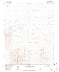
1970 Map of Alkali
USGS Topo · Published 1982About this map
Alkali Hot Spring and the small settlement of Alkali serve as central landmarks in this high-desert landscape of Esmeralda County during the late 1960s. The map illustrates a region defined by its geological extremes, from the low-lying Alkali Lake Alkali Flat (Depression) in the northwest to the elevated heights of the Montezuma Range and Flattop Mtn in the south. A legacy of earlier industrial activity is visible through the Old Railroad Grade running along the eastern edge and various Prospect sites located near Silver Peak Ridge. The transportation network is sparse, consisting largely of the Silver Peak Road and several Jeep Tr paths, suggesting a territory primarily used for mining exploration and ranching, evidenced by a solitary Corral. Natural drainage patterns like Big Wash and Indian Springs Canyon emphasize the arid environment's dependence on seasonal water flow.
Find a feature on this map
18 named features on this map. Tap any name to fly to it.
Don’t see what you’re looking for? This feature index may not catch every label — zoom into the map to look around manually.
Map Details
Editions of this 1970 Alkali Map
2 editions found
Other maps of this area

1908 · Lida
USGS Topo · 1:250,000

1913 · Lida
USGS Topo · 1:250,000

1945 · Goldfield
USGS Topo · 1:125,000

1952 · Mud Lake
USGS Topo · 1:62,500

1952 · Goldfield
USGS Topo · 1:62,500

1954 · Goldfield
USGS Topo · 1:250,000

1955 · Goldfield
USGS Topo · 1:250,000

1958 · Goldfield
USGS Topo · 1:250,000

1962 · Goldfield
USGS Topo · 1:250,000
1970 · Klondike
USGS Topo · 1:24,000