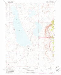
1966 Map of Alkali Lake
USGS Topo · Published 1982About this map
Alkali Lake dominates this high desert basin, situated within the Long Valley (Depression). The landscape is defined by its hydrologic features, with numerous seeps and springs dotting the valley floor, including the named Warm Springs located north of the lake bed. This environment suggests a seasonal water cycle typical of the Great Basin, where surface water is scarce and localized. Human activity is represented by the Bandy Ranch in the southwest and a solitary gravel pit, connected by a network of unimproved routes and a designated Jeep Trail. These elements indicate a territory primarily used for ranching and resource extraction, where life follows the availability of water in an otherwise arid expanse.
Find a feature on this map
9 named features on this map. Tap any name to fly to it.
Don’t see what you’re looking for? This feature index may not catch every label — zoom into the map to look around manually.
Map Details
Editions of this 1966 Alkali Lake Map
2 editions found
Other maps of this area

1889 · Long Valley
USGS Topo · 1:250,000

1954 · Vya
USGS Topo · 1:250,000

1958 · Vya
USGS Topo · 1:250,000

1962 · Vya
USGS Topo · 1:250,000

1966 · Massacre Lake NW
USGS Topo · 1:24,000

1966 · Vya
USGS Topo · 1:24,000
1966 · Mosquito Valley
USGS Topo · 1:24,000
1966 · Calcutta Lake
USGS Topo · 1:24,000
1966 · Carter Reservoir
USGS Topo · 1:24,000

1966 · Alkali Lake
USGS Topo · 1:24,000