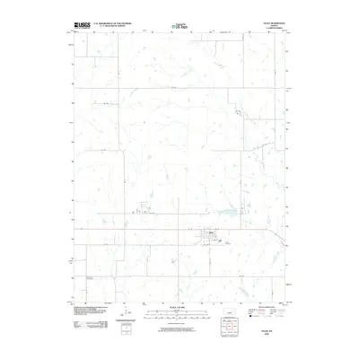
2009 Map of Allen
USGS Topo · Published 2009About this map
Allen sits at the intersection of a vast grid of section roads and the local watershed in Lyon County. The town layout is clearly defined by a traditional street grid including W 1st St, E 3rd St, and E 8th St, showing a compact residential and commercial core. To the north, the Admire-Allen City Lake serves as a significant local landmark and water resource. The surrounding landscape is dominated by a complex network of named waterways, most notably the uniquely named One Hundred and Forty-two Mile Creek and the meandering Bluff Creek. Genealogists will find the locations of Allen Cemetery just southeast of the town site and Bushong Cemetery to the southwest particularly valuable for local research. The prevalence of numbered roads like RD 390 and RD 330 illustrates the organized agricultural partitioning of the Kansas plains.
Find a feature on this map
28 named features on this map. Tap any name to fly to it.
Don’t see what you’re looking for? This feature index may not catch every label — zoom into the map to look around manually.
Map Details
Editions of this 2009 Allen Map
This is the sole edition of this map. No revisions or reprints were ever made.
Other maps of this area

1885 · Eskridge
USGS Topo · 1:125,000

1889 · Eskridge
USGS Topo · 1:125,000

1894 · Eskridge
USGS Topo · 1:125,000

1955 · Hutchinson
USGS Topo · 1:250,000

1959 · Hutchinson
USGS Topo · 1:250,000
1971 · Admire
USGS Topo · 1:24,000

1971 · Alta Vista SE
USGS Topo · 1:24,000

1971 · Allen
USGS Topo · 1:24,000

1971 · Bushong
USGS Topo · 1:24,000
1971 · Lake Wabaunsee
USGS Topo · 1:24,000