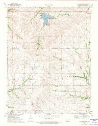
1971 Map of Lake Wabaunsee
USGS Topo · Published 1974About this map
Lake Wabaunsee and its spillway dominate the northern terrain of this Wabaunsee County landscape, where the small settlement of Graves sits near the water's edge. The geography is defined by a dense network of drainages, including Mill Creek, Locust Creek, and the East Branch Rock Creek, which carve through the Flint Hills region. A significant historical marker, the Old Indian Treaty Boundary, cuts diagonally across the center of the sheet, reflecting the early 19th-century geopolitical divisions of Kansas territory.
Find a feature on this map
14 named features on this map. Tap any name to fly to it.
Don’t see what you’re looking for? This feature index may not catch every label — zoom into the map to look around manually.
Map Details
Editions of this 1971 Lake Wabaunsee Map
This is the sole edition of this map. No revisions or reprints were ever made.
Other maps of this area

1885 · Eskridge
USGS Topo · 1:125,000

1889 · Eskridge
USGS Topo · 1:125,000

1894 · Eskridge
USGS Topo · 1:125,000

1955 · Hutchinson
USGS Topo · 1:250,000

1959 · Hutchinson
USGS Topo · 1:250,000
1971 · Admire
USGS Topo · 1:24,000
1971 · Allendorph
USGS Topo · 1:24,000

1971 · Alta Vista SE
USGS Topo · 1:24,000

1971 · Allen
USGS Topo · 1:24,000

1971 · Bushong
USGS Topo · 1:24,000