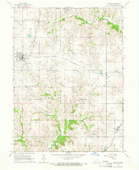
1964 Map of Allerton
USGS Topo · Published 1966About this map
The town of Allerton serves as the primary hub of this Wayne County landscape, situated at a key junction of the Chicago Rock Island and Pacific railroad during the mid-1960s. The region is defined by its agricultural layout and a series of rural family-named cemeteries that provide a clear record of local settlement, including Rankin Cem, Shriver Cem, and Thomas Cem.
Find a feature on this map
25 named features on this map. Tap any name to fly to it.
Don’t see what you’re looking for? This feature index may not catch every label — zoom into the map to look around manually.
Map Details
Editions of this 1964 Allerton Map
This is the sole edition of this map. No revisions or reprints were ever made.
Other maps of this area
1934 · Humeston
USGS Topo · 1:48,000
1935 · Russell
USGS Topo · 1:62,500
1937 · Corydon
USGS Topo · 1:62,500
1938 · Russell
USGS Topo · 1:62,500
1942 · Seymour
USGS Topo · 1:62,500
1944 · Seymour
USGS Topo · 1:62,500

1954 · Centerville
USGS Topo · 1:250,000
1957 · Centerville
USGS Topo · 1:250,000
1958 · Centerville
USGS Topo · 1:250,000
1964 · Cleopatra
USGS Topo · 1:24,000