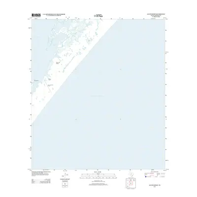
2012 Map of Allyns Bight
USGS Topo · Published 2012About this map
San Jose Island dominates this coastal landscape, separating the shallow reaches of Aransas Bay from the open expanse of the Gulf of Mexico. The barrier island geography is defined by complex water systems, including the inland waters of Allyns Lake and the eponymous Allyns Bight. A human footprint is visible at the Fairmont Ranch and the nearby San Jose Island Airport, which together represent the localized development on this otherwise marshy and low-lying stretch of the Texas coast. Navigation between the island and the mainland is influenced by features like Blind Pass and Mud Island, illustrating the dynamic nature of the Gulf Coast's tidal inlets and sediment-driven landforms.
Find a feature on this map
10 named features on this map. Tap any name to fly to it.
Don’t see what you’re looking for? This feature index may not catch every label — zoom into the map to look around manually.
Map Details
Editions of this 2012 Allyns Bight Map
This is the sole edition of this map. No revisions or reprints were ever made.
Other maps of this area

1925 · Aransas Pass
USGS Topo · 1:62,500

1950 · Corpus Christi
USGS Topo · 1:250,000

1951 · Allyns Bight
USGS Topo · 1:24,000

1952 · St. Charles Bay SW
USGS Topo · 1:24,000

1952 · St. Charles Bay SE
USGS Topo · 1:24,000

1953 · Beeville
USGS Topo · 1:250,000

1954 · Rockport
USGS Topo · 1:62,500

1954 · Estes
USGS Topo · 1:24,000
1954 · Port Aransas
USGS Topo · 1:24,000

1954 · Aransas Pass
USGS Topo · 1:62,500