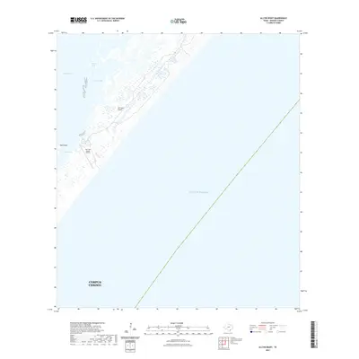
2022 Map of Allyns Bight
USGS Topo · Published 2022About this map
San Jose Island dominates this coastal survey, serving as a protective barrier between the open Gulf of Mexico and the marshy inner reaches of Aransas Bay. This segment of the Texas coastline is characterized by intricate tidal hydrology, where water bodies like Allyns Lake and Long Lake punctuate the shifting sands of the island. The presence of the San Jose Island Airport suggests the continued specialized use of this strip of land, which remains largely separated from the mainland. To the southwest, Mud Island and the narrow opening at Blind Pass illustrate the dynamic nature of the bay's estuary system. This document provides a clear look at the Corpus Christi jurisdictional boundary as it extends into these waters, capturing the modern state of the Allyns Bight shoreline.
Find a feature on this map
10 named features on this map. Tap any name to fly to it.
Don’t see what you’re looking for? This feature index may not catch every label — zoom into the map to look around manually.
Map Details
Editions of this 2022 Allyns Bight Map
This is the sole edition of this map. No revisions or reprints were ever made.
Other maps of this area

1925 · Aransas Pass
USGS Topo · 1:62,500

1950 · Corpus Christi
USGS Topo · 1:250,000

1951 · Allyns Bight
USGS Topo · 1:24,000

1952 · St. Charles Bay SW
USGS Topo · 1:24,000

1952 · St. Charles Bay SE
USGS Topo · 1:24,000

1953 · Beeville
USGS Topo · 1:250,000

1954 · Rockport
USGS Topo · 1:62,500

1954 · Estes
USGS Topo · 1:24,000
1954 · Port Aransas
USGS Topo · 1:24,000

1954 · Aransas Pass
USGS Topo · 1:62,500