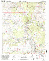
1999 Map of Alma
USGS Topo · Published 2002About this map
Alma and its surrounding ranchlands sit at the confluence of the San Francisco River and Mineral Creek in Catron County. This high-altitude landscape is characterized by a series of mesas and canyons, including Cradle Mesa and Racetrack Mesa, that are deeply integrated into the Gila National Forest and Apache National Forest. The map documents a rugged livestock-driven economy, evidenced by a network of ranch sites like the LH Ranch, W-S Ranch, and the Mc Keen Ranch. A Historical Bridge spans the river near the Spurgeon ranch sites, marking a critical crossing point for local transit. The presence of numerous water management features, such as Alma Tank, Hanging Rocks Tank, and Hells Acre Tank, highlights the essential infrastructure required to sustain agriculture and grazing in this arid terrain. North of the settlement, the Blue Range Wilderness remains largely undeveloped, defined by prominent elevations like Indian Peak.
Find a feature on this map
89 named features on this map. Tap any name to fly to it.
Don’t see what you’re looking for? This feature index may not catch every label — zoom into the map to look around manually.
Map Details
Editions of this 1999 Alma Map
This is the sole edition of this map. No revisions or reprints were ever made.
Other maps of this area

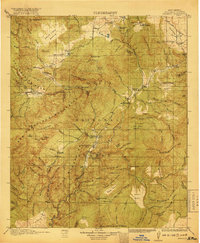
1910 · Mogollon
USGS Topo · 1:125,000

1912 · Mogollon
USGS Topo · 1:125,000

1913 · Morenci
USGS Topo · 1:125,000

1915 · Morenci
USGS Topo · 1:125,000

1915 · Reserve
USGS Topo · 1:125,000
1918 · Reserve
USGS Topo · 1:125,000

1922 · Nutrioso
USGS Topo · 1:125,000

1954 · Clifton
USGS Topo · 1:250,000

1957 · Clifton
USGS Topo · 1:250,000

1958 · Clifton
USGS Topo · 1:250,000