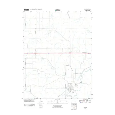
2012 Map of Alma
USGS Topo · Published 2012About this map
Alma serves as the focal point of this Wabaunsee County landscape, where the local community structure is anchored by the Wabaunsee County Fairgrounds and the Post Office near the intersection of Nebraska St and E 6th St. The town is situated just north of the meandering Mill Creek, which is fed by numerous tributaries including S Br Mill Cr and W Br Mill Cr. The surrounding terrain is defined by a dense network of named drainage systems such as Antelope Cr, Paw Paw Cr, and Pretty Cr, highlighting the importance of water management in this part of Kansas. Notable landmarks for local history include the Alma Cem and the distinct geological formation of Clapboard Ravine Canyon to the east. The map also traces the modern influence of the Interstate highway cutting through the rural northern sections near Hinerville Rd.
Find a feature on this map
48 named features on this map. Tap any name to fly to it.
Don’t see what you’re looking for? This feature index may not catch every label — zoom into the map to look around manually.
Map Details
Editions of this 2012 Alma Map
This is the sole edition of this map. No revisions or reprints were ever made.
Other maps of this area

1885 · Eskridge
USGS Topo · 1:125,000

1889 · Wamego
USGS Topo · 1:125,000

1889 · Eskridge
USGS Topo · 1:125,000

1894 · Eskridge
USGS Topo · 1:125,000

1894 · Wamego
USGS Topo · 1:125,000

1953 · Wamego
USGS Topo · 1:24,000

1953 · St George
USGS Topo · 1:24,000

1953 · Belvue
USGS Topo · 1:24,000
1953 · Wamego SW
USGS Topo · 1:24,000

1954 · Alma
USGS Topo · 1:24,000