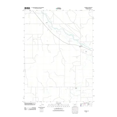
2011 Map of Almeria
USGS Topo · Published 2011About this map
The North Loup River meanders diagonally through this rural Loup County landscape, anchoring the small settlement of Almeria. This 2011 survey illustrates a quiet agricultural region defined by its sections and river access. Local history and genealogy are well-represented by several burial grounds scattered throughout the township, including Moulton Cemetery in the north and Madison Square Cemetery to the south. The village itself is centered near the Almeria Post Office and Almeria Cemetery, marking a long-standing community hub in the Nebraska Sandhills periphery. Transport in the area relies on a grid of gravel routes such as Dry Valley Rd and Knobby Ridge Rd, which trace the higher ground away from the river's winding path.
Find a feature on this map
10 named features on this map. Tap any name to fly to it.
Don’t see what you’re looking for? This feature index may not catch every label — zoom into the map to look around manually.
Map Details
Editions of this 2011 Almeria Map
This is the sole edition of this map. No revisions or reprints were ever made.
Other maps of this area

1951 · Walworth
USGS Topo · 1:24,000

1951 · Milburn
USGS Topo · 1:24,000

1952 · Taylor NW
USGS Topo · 1:24,000

1952 · Almeria NE
USGS Topo · 1:24,000

1952 · Sargent West
USGS Topo · 1:24,000

1952 · Almeria NW
USGS Topo · 1:24,000

1952 · Almeria SW
USGS Topo · 1:24,000

1952 · Almeria
USGS Topo · 1:24,000

1952 · Taylor
USGS Topo · 1:24,000

1955 · Broken Bow
USGS Topo · 1:250,000